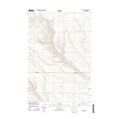
2013 Map of Prosser SW
USGS Topo · Published 2013About this map
Glade Cr carves a deep drainage through the undulating plateau of the Horse Heaven Hills, forming the primary geographic axis for this rural landscape on the border of Yakima and Klickitat counties. This 2013 survey illustrates a region defined by high-elevation land management and a sparse network of section-line and canyon-bottom roads. The terrain transitions from the higher reaches of the plateau down toward Coyote Canyon in the southeast, where the elevation drops significantly into more dissected draws. A network of arterial routes such as Alderdale Rd and Wandling Rd provides the only infrastructure across these townships, reflecting a landscape dominated by large-scale agricultural or conservation use rather than residential settlement. The survey clearly delineates the Yakima Co Klickitat Co boundary, which cuts east-to-west across the northern portion of the quadrangle.
Find a feature on this map
16 named features on this map. Tap any name to fly to it.
Don’t see what you’re looking for? This feature index may not catch every label — zoom into the map to look around manually.
Map Details
Editions of this 2013 Prosser SW Map
This is the sole edition of this map. No revisions or reprints were ever made.
Other maps of this area

1906 · Blalock Island
USGS Topo · 1:125,000

1908 · Blalock Island
USGS Topo · 1:125,000

1910 · Zillah
USGS Topo · 1:125,000

1915 · Prosser
USGS Topo · 1:125,000

1916 · Arlington
USGS Topo · 1:125,000

1917 · Prosser
USGS Topo · 1:125,000

1950 · Yakima
USGS Topo · 1:250,000

1953 · Pendleton
USGS Topo · 1:250,000

1953 · Walla Walla
USGS Topo · 1:250,000

1953 · The Dalles
USGS Topo · 1:250,000