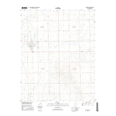
2015 Map of Protection
USGS Topo · Published 2015About this map
The town of Protection serves as the focal point of this Comanche County survey, situated at the intersection of local routes like Broadway Ave and N Jefferson Ave. The street grid is clearly defined, featuring local landmarks such as W Walnut St and E Olive St. To the northwest, the Protection Cem stands near the banks of Bluff Cr, marking a key site for genealogical research. The surrounding landscape is defined by a network of drainage systems, including the prominent Cavalry Cr which meanders through the central and eastern portions of the quadrangle. Other watercourses like Kiowa Cr and Buzzard Cr further delineate the prairie terrain. The map captures the organized section lines of T32S and T33S, illustrating the enduring agricultural and rural road network that characterizes this part of the Kansas plains.
Find a feature on this map
41 named features on this map. Tap any name to fly to it.
Don’t see what you’re looking for? This feature index may not catch every label — zoom into the map to look around manually.
Map Details
Editions of this 2015 Protection Map
This is the sole edition of this map. No revisions or reprints were ever made.
Other maps of this area

1892 · Coldwater
USGS Topo · 1:125,000

1894 · Sitka
USGS Topo · 1:62,500

1896 · Ashland
USGS Topo · 1:125,000

1955 · Pratt
USGS Topo · 1:250,000

1959 · Pratt
USGS Topo · 1:250,000

1979 · Sugarloaf
USGS Topo · 1:24,000

1979 · Coldwater
USGS Topo · 1:24,000

1979 · East Kiowa Creek South
USGS Topo · 1:24,000
1979 · Lexington
USGS Topo · 1:24,000

1979 · Protection NE
USGS Topo · 1:24,000