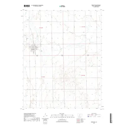
2018 Map of Protection
USGS Topo · Published 2018About this map
Protection sits at the intersection of a vast grid of section roads and the winding path of Cavalry Cr, illustrating the rigid township and range system typical of the High Plains. The town site is meticulously detailed with its primary thoroughfares including E Main St, S Broadway Ave, and S Jefferson Ave. This 2018 survey reveals a community deeply connected to the drainage basins of Bluff Cr and Kiowa Cr, which break the geometric regularity of the surrounding agricultural landscape. Just northwest of the main town site, the Protection Cem serves as a key landmark for genealogical research, while the surrounding landscape is marked by numerous small ponds and ephemeral watercourses. The persistence of the local road network, from CM Rd 4 to CM Ave K, shows how infrastructure continues to follow the historic survey lines established generations ago.
Find a feature on this map
43 named features on this map. Tap any name to fly to it.
Don’t see what you’re looking for? This feature index may not catch every label — zoom into the map to look around manually.
Map Details
Editions of this 2018 Protection Map
This is the sole edition of this map. No revisions or reprints were ever made.
Other maps of this area

1892 · Coldwater
USGS Topo · 1:125,000

1894 · Sitka
USGS Topo · 1:62,500

1896 · Ashland
USGS Topo · 1:125,000

1955 · Pratt
USGS Topo · 1:250,000

1959 · Pratt
USGS Topo · 1:250,000

1979 · Sugarloaf
USGS Topo · 1:24,000

1979 · Coldwater
USGS Topo · 1:24,000

1979 · East Kiowa Creek South
USGS Topo · 1:24,000
1979 · Lexington
USGS Topo · 1:24,000

1979 · Protection NE
USGS Topo · 1:24,000