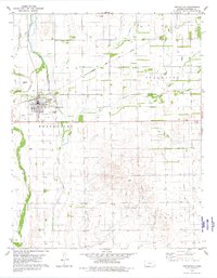
1980 Map of Protection
USGS Topo · Published 1980About this map
Protection serves as the central hub of this prairie landscape in south-central Kansas, situated at the crossroads of rail and road. The Atchison Topeka and Santa Fe railroad corridor cuts across the northern territory, marking the town's historic connection to regional commerce. This 1980 survey captures a community well-equipped with local infrastructure, including a Municipal Airport and a Golf Course on the town's southern edge. To the west, the Protection Cem stands near the banks of Bluff Creek.
Find a feature on this map
16 named features on this map. Tap any name to fly to it.
Don’t see what you’re looking for? This feature index may not catch every label — zoom into the map to look around manually.
Map Details
Editions of this 1980 Protection Map
This is the sole edition of this map. No revisions or reprints were ever made.
Other maps of this area

1892 · Coldwater
USGS Topo · 1:125,000

1894 · Sitka
USGS Topo · 1:62,500

1896 · Ashland
USGS Topo · 1:125,000

1955 · Pratt
USGS Topo · 1:250,000

1959 · Pratt
USGS Topo · 1:250,000

1979 · Sugarloaf
USGS Topo · 1:24,000

1979 · Coldwater
USGS Topo · 1:24,000

1979 · East Kiowa Creek South
USGS Topo · 1:24,000
1979 · Lexington
USGS Topo · 1:24,000

1979 · Protection NE
USGS Topo · 1:24,000