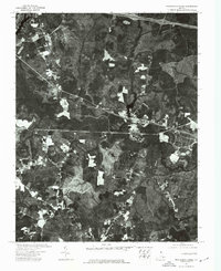
1974 Map of Providence Forge
USGS Topo · Published 1977About this map
Providence Forge serves as the central hub of this mid-1970s orthophotoquad, where the landscape is defined by the winding course of the Chickahominy River. Unlike traditional topographic maps, this aerial perspective reveals the raw texture of New Kent's timberlands, clearings, and floodplain swamps as they appeared in 1974. The river’s intricate meanders and oxbows dominate the lower half of the frame, illustrating the natural drainage patterns that have historically shaped local land use and boundary lines. The settlement at Providence Forge is clearly visible as a concentration of structures and cleared lots at a critical transition point in the terrain. This document, produced by the U.S. Geological Survey and the Virginia Division of Mineral Resources, offers a rare photographic record of rural Virginia before modern suburban expansion significantly altered the visual character of the region.
Find a feature on this map
2 named features on this map. Tap any name to fly to it.
Don’t see what you’re looking for? This feature index may not catch every label — zoom into the map to look around manually.
Map Details
Editions of this 1974 Providence Forge Map
This is the sole edition of this map. No revisions or reprints were ever made.
Other maps of this area

1917 · Toano
USGS Topo · 1:62,500

1918 · Charles City
USGS Topo · 1:62,500

1918 · Toano
USGS Topo · 1:62,500

1919 · New Kent
USGS Topo · 1:62,500

1920 · King William
USGS Topo · 1:62,500

1943 · Richmond
USGS Topo · 1:250,000
1949 · Quinton
USGS Topo · 1:24,000

1949 · Tunstall
USGS Topo · 1:24,000

1949 · New Kent
USGS Topo · 1:24,000

1949 · Richmond
USGS Topo · 1:250,000