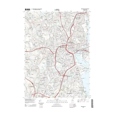
2015 Map of Providence
USGS Topo · Published 2015About this map
The Moshassuck River and Seekonk River converge in this densely populated urban corridor, where the historic core of Pawtucket meets the state capital. This survey illustrates a landscape deeply shaped by education and public memory, featuring the campuses of Brown Univ, Rhode Island Coll, and the Rhode Island Sch of Design. Large memorial spaces such as the North Burial Ground and Swan Point Cem flank the riverbanks, while the Roger Williams National Memorial anchors the center of the city near the Crawford Street Bridge. Industrial roots remain visible in place names and infrastructure, from the Cranston Print Works Pond in the west to the active waterfront at Providence Harbor. Neighborhoods like Olneyville, Manton, and Fruit Hill show the tight residential patterns of the early 21st century, punctuated by reservoirs such as Wenscott Reservoir that historically supported the region's textile and manufacturing development.
Find a feature on this map
147 named features on this map. Tap any name to fly to it.
Don’t see what you’re looking for? This feature index may not catch every label — zoom into the map to look around manually.
Map Details
Editions of this 2015 Providence Map
This is the sole edition of this map. No revisions or reprints were ever made.
Other maps of this area

1887 · Providence
USGS Topo · 1:62,500

1889 · Providence
USGS Topo · 1:62,500

1889 · Burrillville
USGS Topo · 1:62,500

1890 · Narragansett Bay
USGS Topo · 1:62,500

1890 · Kent
USGS Topo · 1:62,500

1892 · Narragansett Bay
USGS Topo · 1:62,500

1894 · Burrillville
USGS Topo · 1:62,500

1894 · Kent
USGS Topo · 1:62,500

1894 · Providence
USGS Topo · 1:62,500

1915 · Burrillville
USGS Topo · 1:62,500