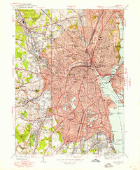
1935 Map of Providence
USGS Topo · Published 1958About this map
Providence and its surrounding mill villages appear at a peak of industrial and urban density in this mid-1930s topographic record. The landscape is defined by the Woonasquatucket River and the Pawtuxet River, which powered the development of communities like Olneyville, Manton, and Allendale. Extensive institutional grounds occupy large tracts of the city, from the academic campus of Brown University to the specialized facilities of the State Home for Children and the Dexter Asylum.
Find a feature on this map
158 named features on this map. Tap any name to fly to it.
Don’t see what you’re looking for? This feature index may not catch every label — zoom into the map to look around manually.
Map Details
Editions of this 1935 Providence Map
This is the sole edition of this map. No revisions or reprints were ever made.
Other maps of this area

1887 · Providence
USGS Topo · 1:62,500

1889 · Providence
USGS Topo · 1:62,500

1889 · Burrillville
USGS Topo · 1:62,500

1890 · Narragansett Bay
USGS Topo · 1:62,500

1890 · Kent
USGS Topo · 1:62,500

1892 · Narragansett Bay
USGS Topo · 1:62,500

1894 · Burrillville
USGS Topo · 1:62,500

1894 · Kent
USGS Topo · 1:62,500

1894 · Providence
USGS Topo · 1:62,500

1915 · Burrillville
USGS Topo · 1:62,500