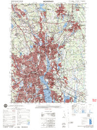
1979 Map of Providence
USGS Topo · Published 1979About this map
Providence and its surrounding industrial corridor appear here at the end of the 1970s, defined by the convergence of the Blackstone River and Pawtuxet River into the Providence Harbor. The map reveals a densely developed urban landscape where older neighborhoods like Olneyville and Pawtuxet are bisected by the modern paths of Interstate 95 and Interstate 195. To the north, the textile heritage of the valley is evident in the layout of Central Falls, Valley Falls, and Lonsdale.
Find a feature on this map
160 named features on this map. Tap any name to fly to it.
Don’t see what you’re looking for? This feature index may not catch every label — zoom into the map to look around manually.
Map Details
Editions of this 1979 Providence Map
This is the sole edition of this map. No revisions or reprints were ever made.
Other maps of this area

1885 · Taunton
USGS Topo · 1:62,500

1886 · Blackstone
USGS Topo · 1:62,500

1886 · Dedham
USGS Topo · 1:62,500

1887 · Franklin
USGS Topo · 1:62,500

1887 · Providence
USGS Topo · 1:62,500

1888 · Fall River
USGS Topo · 1:62,500

1888 · Taunton
USGS Topo · 1:62,500

1889 · Providence
USGS Topo · 1:62,500

1889 · Blackstone
USGS Topo · 1:62,500

1889 · Franklin
USGS Topo · 1:62,500