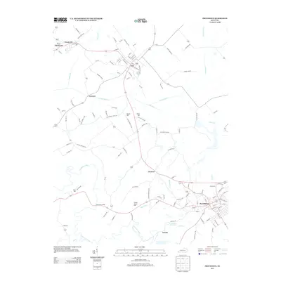
2013 Map of Providence
USGS Topo · Published 2013About this map
Providence serves as the primary hub in this early 21st-century survey of Webster County, anchored by a network of streets including L and N Railroad Bed, which speaks to the area's industrial history. To the northwest, the settlements of Clay, Wheatcroft, and West Wheatcroft are connected by a web of rural routes and coal-country roads like Fairmont Mine Rd and Five Mine Rd. The geography is defined by the winding Tradewater River and its tributaries, including Whiteside Cr and Craborchard Cr, while the high ground is marked by prominent elevations such as Clifty Hill and Nesbit Hill. Smaller communities like Diamond and Bellville appear near Providence City Lake, highlighting a pattern of settlement closely tied to the regional hydrology and mineral resources of the Western Kentucky Coal Field. Features like the Montezuma Bridge provide specific points of interest for those tracing historical transportation corridors across the river valley.
Find a feature on this map
118 named features on this map. Tap any name to fly to it.
Don’t see what you’re looking for? This feature index may not catch every label — zoom into the map to look around manually.
Map Details
Editions of this 2013 Providence Map
This is the sole edition of this map. No revisions or reprints were ever made.
Other maps of this area

1906 · Sebree
USGS Topo · 1:62,500

1907 · Earlington
USGS Topo · 1:48,000

1907 · Morganfield
USGS Topo · 1:62,500

1909 · Earlington
USGS Topo · 1:62,500

1909 · Providence
USGS Topo · 1:62,500

1951 · Dixon
USGS Topo · 1:24,000
1951 · Bordley
USGS Topo · 1:24,000

1951 · Sturgis
USGS Topo · 1:24,000

1954 · Evansville
USGS Topo · 1:250,000
1954 · Nebo
USGS Topo · 1:24,000