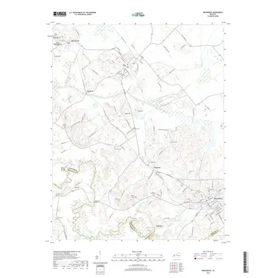
2019 Map of Providence
USGS Topo · Published 2019About this map
Wheatcroft and Clay anchor this portion of the Western Kentucky Coal Field, where industrial remnants like the L & N Railroad Bed trace the historical movement of resources through Webster County. The landscape is defined by its drainages, particularly the Tradewater River and Craborchard Creek, which wind through lowlands like Black Rough Bottom. The map reveals a densely settled rural pattern with numerous family and community burial grounds, such as the Odd Fellows Cem, Blackwell Cem, and Fraser - Blackwell Cem, reflecting generations of local lineage.
Find a feature on this map
125 named features on this map. Tap any name to fly to it.
Don’t see what you’re looking for? This feature index may not catch every label — zoom into the map to look around manually.
Map Details
Editions of this 2019 Providence Map
This is the sole edition of this map. No revisions or reprints were ever made.
Other maps of this area

1906 · Sebree
USGS Topo · 1:62,500

1907 · Earlington
USGS Topo · 1:48,000

1907 · Morganfield
USGS Topo · 1:62,500

1909 · Earlington
USGS Topo · 1:62,500

1909 · Providence
USGS Topo · 1:62,500

1951 · Dixon
USGS Topo · 1:24,000
1951 · Bordley
USGS Topo · 1:24,000

1951 · Sturgis
USGS Topo · 1:24,000

1954 · Evansville
USGS Topo · 1:250,000
1954 · Nebo
USGS Topo · 1:24,000