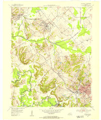
1954 Map of Providence
USGS Topo · Published 1955About this map
The industrial coal-mining landscape of western Kentucky is captured here at a moment of transition during the early 1950s. The Illinois Central and Louisville And Nashville railroads dominate the logistics of the region, connecting towns like Providence and Clay to wider markets. The terrain is defined by a heavy concentration of Strip Mines and specific operations like Mine No 5 and Fairmont Mine, which appear alongside the residential and religious heart of these communities.
Find a feature on this map
64 named features on this map. Tap any name to fly to it.
Don’t see what you’re looking for? This feature index may not catch every label — zoom into the map to look around manually.
Map Details
Editions of this 1954 Providence Map
This is the sole edition of this map. No revisions or reprints were ever made.
Other maps of this area

1906 · Sebree
USGS Topo · 1:62,500

1907 · Earlington
USGS Topo · 1:48,000

1907 · Morganfield
USGS Topo · 1:62,500

1909 · Earlington
USGS Topo · 1:62,500

1909 · Providence
USGS Topo · 1:62,500

1951 · Dixon
USGS Topo · 1:24,000
1951 · Bordley
USGS Topo · 1:24,000

1951 · Sturgis
USGS Topo · 1:24,000

1954 · Evansville
USGS Topo · 1:250,000
1954 · Nebo
USGS Topo · 1:24,000