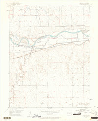
1953 Map of Prowers
USGS Topo · Published 1963About this map
Bents New Fort (Ruins) and the Old Santa Fe Trail define the cultural history of this reach of the Arkansas River in Bent County. The map documents a landscape where 19th-century frontier transit routes intersect with mid-20th-century irrigation and rail infrastructure. Along the river, the Big Timbers area serves as a focal point for local history, featuring an Historical Marker and several burial sites including The Home Cemetery and a simple Graveyard. The economy of the era is evident in the complex network of water management features like the Keesee Canal, Fort Bent Canal, and Sunflower Ditch, which supported agricultural development near the small settlement of Prowers. The Atchison Topeka and Santa Fe railroad tracks run parallel to the old trail, illustrating the transition from wagon ruts to iron rails through the high plains.
Find a feature on this map
23 named features on this map. Tap any name to fly to it.
Don’t see what you’re looking for? This feature index may not catch every label — zoom into the map to look around manually.
Map Details
Editions of this 1953 Prowers Map
3 editions found
Other maps of this area

1892 · Lamar
USGS Topo · 1:125,000

1892 · Two Butte
USGS Topo · 1:125,000

1893 · Two Butte
USGS Topo · 1:125,000

1952 · Lamar West
USGS Topo · 1:24,000

1953 · Hasty
USGS Topo · 1:24,000

1953 · Prowers
USGS Topo · 1:24,000

1954 · Lamar
USGS Topo · 1:250,000

1955 · McClave
USGS Topo · 1:24,000

1955 · Lubers
USGS Topo · 1:24,000

1955 · Wiley
USGS Topo · 1:24,000