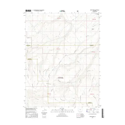
2016 Map of Pryor Creek
USGS Topo · Published 2016About this map
Uncompahgre National Forest dominates this high-altitude landscape along the border of Montrose and Ouray Counties. The terrain is defined by the massive Uncompahgre Plateau and deep cuts like DeVinney Canyon, creating a complex network of drainage basins. Numerous seasonal and perennial waterways, including Pryor Creek, Cottonwood Cr, and the Middle Fork Spring Cr, have carved the landscape into a series of ridges and valleys. Human passage through this environment is primarily marked by a significant network of historic routes and pack paths. The Old Paradox Trail and its successor, the Paradox Trail, wind through the center of the sheet, while more specific paths like the Dented Door Trail and Spring Creek Spur suggest a legacy of forest management, ranching, and backcountry travel. Notable hydrological features such as Silesca Pond and Beaver Dams indicate localized water points in an otherwise high-elevation wilderness.
Find a feature on this map
35 named features on this map. Tap any name to fly to it.
Don’t see what you’re looking for? This feature index may not catch every label — zoom into the map to look around manually.
Map Details
Editions of this 2016 Pryor Creek Map
This is the sole edition of this map. No revisions or reprints were ever made.
Other maps of this area

1909 · Montrose
USGS Topo · 1:125,000

1911 · Montrose
USGS Topo · 1:125,000

1956 · Montrose
USGS Topo · 1:250,000

1956 · Moab
USGS Topo · 1:250,000

1959 · Moab
USGS Topo · 1:250,000

1959 · Montrose
USGS Topo · 1:250,000

1960 · Montrose
USGS Topo · 1:250,000

1960 · Moab
USGS Topo · 1:250,000

1962 · Moab
USGS Topo · 1:250,000
1962 · Montrose West
USGS Topo · 1:24,000