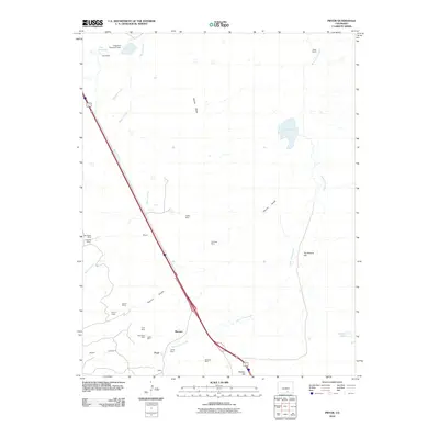
2010 Map of Pryor
USGS Topo · Published 2010About this map
Pryor and the surrounding high plains of Huerfano County are defined by a long history of coal extraction, evidenced by the numerous mining sites dotting the drainage basins of Santa Clara Creek and Mayne Arroyo. The industrial footprint of the early 20th century remains visible through labels for the Rugby Mine, Hezron Mines, and the Old Rouse Mine. Small settlements like Lester, Monson, and Mayne cluster near these former hubs of production, while the landscape rises toward distinctive landforms such as Salida Mesa and Tombstone Hill. Water management in this arid environment is highlighted by the Levy Reservoir and Saliba Lake. This 2010 survey provides a modern look at how transportation corridors follow the older tracks of commerce, with the major highway route cutting a direct path through the heart of the historic mining district.
Find a feature on this map
29 named features on this map. Tap any name to fly to it.
Don’t see what you’re looking for? This feature index may not catch every label — zoom into the map to look around manually.
Map Details
Editions of this 2010 Pryor Map
This is the sole edition of this map. No revisions or reprints were ever made.
Other maps of this area

1891 · Walsenburg
USGS Topo · 1:125,000

1891 · Spanish Peaks
USGS Topo · 1:125,000

1893 · Spanish Peaks
USGS Topo · 1:125,000

1894 · Walsenburg
USGS Topo · 1:125,000

1895 · Spanish Peaks
USGS Topo · 1:125,000

1897 · Walsenburg
USGS Topo · 1:125,000

1897 · Spanish Peaks
USGS Topo · 1:125,000

1900 · Spanish Peaks
USGS Topo · 1:125,000

1900 · Walsenburg
USGS Topo · 1:125,000

1954 · Trinidad
USGS Topo · 1:250,000