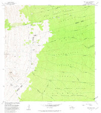
1981 Map of Pua Akala
USGS Topo · Published 1981About this map
Mauna Kea Forest Reserve and the Hilo Forest Reserve define this landscape on the eastern slopes of the Big Island, where the North Hilo District meets the South Hilo District. The map documents a transition from the volcanic heights of Puu Kahinahina and Aahuwela down through the densely carved gulches of the mid-elevation forests. High-altitude outposts such as Kanakaleonui Cabin, Hopuwai, and the Laumaia (Site) are connected by the winding Keanakolu Road, indicating a history of forestry and ranching access. The complex drainage network is anchored by the Wailuku River and numerous perennial flows like Hakalau Stream and Honolii Stream. Of particular interest to local historians is the Spring Water Camp and the presence of a Cinder Pit near the district boundary, marking small-scale industrial activity in this watershed environment.
Find a feature on this map
34 named features on this map. Tap any name to fly to it.
Don’t see what you’re looking for? This feature index may not catch every label — zoom into the map to look around manually.
Map Details
Editions of this 1981 Pua Akala Map
This is the sole edition of this map. No revisions or reprints were ever made.
Other maps of this area

1915 · Honomu
USGS Topo · 1:62,500

1917 · Hilo
USGS Topo · 1:62,500

1930 · Humuula
USGS Topo · 1:62,500

1932 · Hilo
USGS Topo · 1:62,500

1954 · Hawaii North
USGS Topo · 1:250,000

1956 · Puu Oo
USGS Topo · 1:24,000

1956 · Pua Akala
USGS Topo · 1:24,000

1956 · Keanakolu
USGS Topo · 1:24,000

1956 · Upper Piihonua
USGS Topo · 1:24,000

1956 · Mauna Kea
USGS Topo · 1:24,000