1961 Map of Pueblo Pintado
USGS Topo · Published 1982About this map
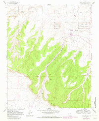
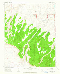
Chaco Canyon National Monument anchors this 1960s survey of the high desert landscape in McKinley County, capturing a region where ancient history and modern infrastructure meet. The map reveals the layout of the Pueblo Pintado settlement, including the Pueblo Pintado Sch and a Pueblo Pintado Landing Strip that serve this remote community. Ancient habitation is marked by several Ruins and a Cliff Dwelling situated along the slopes of Pueblo Pintado Canyon. The terrain is dominated by the broad expanse of Chaco Mesa, dissected by drainage systems like Chaco Wash and Burning Wash. Water sources such as Ramona Spring and a simple Spring appear as critical points in the arid environment. A prominent Pipeline cuts across the canyon floor, illustrating the mid-century industrial overlay on this traditional Navajo and ancestral Puebloan territory.
Find a feature on this map
17 named features on this map. Tap any name to fly to it.
Don’t see what you’re looking for? This feature index may not catch every label — zoom into the map to look around manually.
Map Details
Editions of this 1961 Pueblo Pintado Map
2 editions found
Other maps of this area

1883 · Mt. Taylor
USGS Topo · 1:250,000

1886 · Mt. Taylor
USGS Topo · 1:250,000

1889 · Largo
USGS Topo · 1:250,000

1892 · Mt. Taylor
USGS Topo · 1:250,000

1895 · Largo
USGS Topo · 1:250,000

1899 · Mt. Taylor
USGS Topo · 1:250,000

1954 · Aztec
USGS Topo · 1:250,000

1958 · Aztec
USGS Topo · 1:250,000

1958 · Albuquerque
USGS Topo · 1:250,000
1960 · Pueblo Alto Trading Post
USGS Topo · 1:24,000
Featured Places
- Eastern Navajo Agency, NM
- Pueblo Pintado, Eastern Navajo Agency
- McKinley County, NM
- United States
- New Mexico