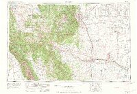
1954 Map of Pueblo
USGS Topo · Published 1973About this map
The Arkansas River valley serves as the central industrial and transportation artery in this mid-century survey, anchoring the growing cities of Pueblo and Colorado Springs. The landscape is defined by a massive military presence, from the sprawling Fort Carson Military Reservation to the Pueblo Ordnance Depot and Ent Air Force Base. To the west, the high peaks of the Front Range and the Sangre de Cristo Mountains rise sharply, dominated by Pikes Peak and the wilderness of the Pike National Forest.
Find a feature on this map
227 named features on this map. Tap any name to fly to it.
Don’t see what you’re looking for? This feature index may not catch every label — zoom into the map to look around manually.
Map Details
Editions of this 1954 Pueblo Map
3 editions found

Other maps of this area

1889 · Canon City
USGS Topo · 1:125,000

1889 · Leadville
USGS Topo · 1:125,000

1889 · Huerfano Park
USGS Topo · 1:125,000

1889 · Sanborn
USGS Topo · 1:125,000

1891 · Walsenburg
USGS Topo · 1:125,000

1891 · Sanborn
USGS Topo · 1:125,000

1891 · Catlin
USGS Topo · 1:125,000

1891 · Pueblo
USGS Topo · 1:125,000

1891 · Timpas
USGS Topo · 1:125,000

1891 · Nepesta
USGS Topo · 1:125,000