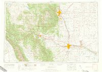
1954 Map of Pueblo
USGS Topo · Published 1973About this map
The Arkansas River valley serves as the primary industrial and agricultural corridor in this 1950s survey, connecting Pueblo and Canon City. This era shows the region balanced between its deep mining roots and expanding Cold War military footprints, anchored by the Fort Carson Military Reservation and the Pueblo Ordnance Depot. To the west, the Sangre De Cristo Mountains and Wet Mountains dominate the horizon, where resources were extracted from sites like the Orient Mine and Canon Imperial Mine. The map details the complex rail network required for such industry, including the Atchison Topeka and Santa Fe and the Denver and Rio Grande Western. High-altitude landmarks like Pikes Peak overlook developing urban centers like Colorado Springs, while rural life is documented through numerous country schools such as Edison School and Grandview School.
Find a feature on this map
199 named features on this map. Tap any name to fly to it.
Don’t see what you’re looking for? This feature index may not catch every label — zoom into the map to look around manually.
Map Details
Editions of this 1954 Pueblo Map
3 editions found

Other maps of this area

1889 · Canon City
USGS Topo · 1:125,000

1889 · Leadville
USGS Topo · 1:125,000

1889 · Huerfano Park
USGS Topo · 1:125,000

1889 · Sanborn
USGS Topo · 1:125,000

1891 · Walsenburg
USGS Topo · 1:125,000

1891 · Sanborn
USGS Topo · 1:125,000

1891 · Catlin
USGS Topo · 1:125,000

1891 · Pueblo
USGS Topo · 1:125,000

1891 · Timpas
USGS Topo · 1:125,000

1891 · Nepesta
USGS Topo · 1:125,000