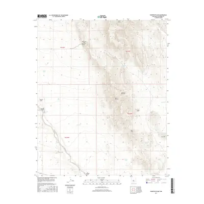
2017 Map of Puertecito Gap
USGS Topo · Published 2017About this map
The Magdalena Mountains dominate this high-desert landscape in Socorro County, where extreme relief is defined by the Devils Backbone and the notable Bern Peak. This 2017 study illustrates a network of essential water sources in an arid environment, including Buffalo Tank, Escondido Tank, and Horse Mountain Tank, which were critical for the livestock operations that once defined the region. The map tracks the passage of Puertecito Arroyo through the complex terrain of the Indian Hills and into Puertecito Canyon. Evidence of early territorial infrastructure remains visible through the grid of the Public Land Survey System, which divides the rugged canyons and peaks near Milligan Gulch. This modern survey preserves the locations of numerous historic tanks and named canyons, such as Rosedale Canyon and Copper Canyon, providing a detailed look at how topographic features dictated the movement of people and resources through Puertecito Gap.
Find a feature on this map
29 named features on this map. Tap any name to fly to it.
Don’t see what you’re looking for? This feature index may not catch every label — zoom into the map to look around manually.
Map Details
Editions of this 2017 Puertecito Gap Map
This is the sole edition of this map. No revisions or reprints were ever made.
Other maps of this area

1954 · Tularosa
USGS Topo · 1:250,000

1958 · Tularosa
USGS Topo · 1:250,000

1961 · Hickman Ranch
USGS Topo · 1:24,000

1961 · Fort Craig
USGS Topo · 1:24,000

1964 · San Juan Peak
USGS Topo · 1:24,000
1965 · Tenmile Hill
USGS Topo · 1:24,000
1965 · Squaw Peak
USGS Topo · 1:24,000
1965 · Puertecito Gap
USGS Topo · 1:24,000
1965 · South Baldy
USGS Topo · 1:24,000
1965 · Molino Peak
USGS Topo · 1:24,000