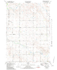
1983 Map of Pukwana NE
USGS Topo · Published 1983About this map
Crow Creek Indian Reservation lands dominate the northern reaches of this rural landscape, representing a significant historical boundary in central South Dakota. The terrain is defined by the branching drainages of Crow Creek and Smith Creek, which cut through the prairie and create a network of draws and breaks. Photogrammetric data from the late 1970s and 1980 reveals a high-plains environment largely dedicated to open range and sparse agricultural infrastructure. The map illustrates how these watercourses dictate the placement of local roads and property boundaries, showing a place where natural topography remains the primary influence on land use and movement.
Find a feature on this map
3 named features on this map. Tap any name to fly to it.
Don’t see what you’re looking for? This feature index may not catch every label — zoom into the map to look around manually.
Map Details
Editions of this 1983 Pukwana NE Map
This is the sole edition of this map. No revisions or reprints were ever made.
Other maps of this area

1941 · Pukwana
USGS Topo · 1:62,500

1941 · Kimball North
USGS Topo · 1:62,500

1951 · Pukwana
USGS Topo · 1:62,500

1951 · Kimball North
USGS Topo · 1:62,500

1953 · Huron
USGS Topo · 1:250,000

1954 · Huron
USGS Topo · 1:250,000

1955 · Mitchell
USGS Topo · 1:250,000

1959 · Mitchell
USGS Topo · 1:250,000

1973 · Big Bend Dam 4 SE
USGS Topo · 1:24,000

1973 · Gannvalley
USGS Topo · 1:24,000
Featured Places
- Union Township, SD
- Pershing Township, SD
- Lyon Township, SD
- Crow Creek District, SD
- Eldorado Township, SD