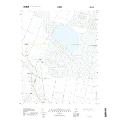
2019 Map of Pungo Lake
USGS Topo · Published 2019About this map
Pungo Lake dominates this low-lying landscape in eastern North Carolina, where the borders of Washington, Hyde, and Beaufort Counties converge. The terrain is characterized by a complex network of artificial waterways and natural rises, reflecting a long history of drainage and agricultural adaptation. Prominent ridges such as Dogwood Ridge, Brights Ridge, and Chinquapin Ridge provide slight elevation above the surrounding wetlands. This 2019 survey detail illustrates the intersection of human engineering and the coastal plain environment, featuring an extensive canal system including the Oregon Canal, Pungo River Canal, and Pungo Lake Canal. Small settlements like Union Grove and Pungo serve as local hubs along a grid of rural roads such as Grassy Ridge Rd and Refuge Rd. The presence of features like Bog Scattering Pines and the White Cypress Tributary highlights the unique ecological character of this marshy region.
Find a feature on this map
42 named features on this map. Tap any name to fly to it.
Don’t see what you’re looking for? This feature index may not catch every label — zoom into the map to look around manually.
Map Details
Editions of this 2019 Pungo Lake Map
This is the sole edition of this map. No revisions or reprints were ever made.
Other maps of this area

1914 · Belhaven
USGS Topo · 1:48,000

1916 · Belhaven
USGS Topo · 1:62,500

1943 · Columbia
USGS Topo · 1:125,000

1943 · Plymouth
USGS Topo · 1:125,000

1951 · Belhaven
USGS Topo · 1:24,000

1951 · Pantego
USGS Topo · 1:24,000

1951 · Ponzer
USGS Topo · 1:24,000

1953 · Rocky Mount
USGS Topo · 1:250,000

1954 · Rocky Mount
USGS Topo · 1:250,000

1954 · Plymouth East
USGS Topo · 1:24,000