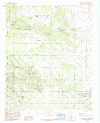
1986 Map of Punta De Agua
USGS Topo · Published 1986About this map
The Salinas Natl Mon (Quarai Division) anchors this mid-1980s provisional study, highlighting a landscape where historical preservation meets the rugged margins of the Cibola National Forest. The map documents the northern reaches of Torrance County, centered on the Town of Manzano Grant Boundary and the small settlements of Montaño and Punta de Agua. This area is defined by its dramatic drainage systems, including Cañon de la Gotera and Cañon Sapato, which carve through the high terrain east of the Manzano Mountains. Local industry and land use are reflected in the various Gravel Pits and the proximity of Manzano State Park. Water sources like Three Springs and Cottonwood Spring provide essential points of reference in this arid environment, illustrating the geographic constraints that have shaped local habitation and ranching patterns for generations.
Find a feature on this map
18 named features on this map. Tap any name to fly to it.
Don’t see what you’re looking for? This feature index may not catch every label — zoom into the map to look around manually.
Map Details
Editions of this 1986 Punta De Agua Map
This is the sole edition of this map. No revisions or reprints were ever made.
Other maps of this area

1917 · Estancia
USGS Topo · 1:125,000

1954 · Capilla Peak
USGS Topo · 1:24,000

1954 · Torreon
USGS Topo · 1:24,000

1954 · Torreon
USGS Topo · 1:62,500

1954 · Socorro
USGS Topo · 1:250,000

1956 · Mountainair
USGS Topo · 1:62,500

1958 · Socorro
USGS Topo · 1:250,000

1962 · Socorro
USGS Topo · 1:250,000

1972 · Abo
USGS Topo · 1:24,000
1972 · Scholle
USGS Topo · 1:24,000