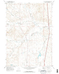
1970 Map of Purdy Reservoir
USGS Topo · Published 1973About this map
TA Hills dominate this portion of Johnson County, where the landscape is defined by the convergence of the forks of Crazy Woman Creek. The 1970 field check documents a rural landscape where water management and ranching infrastructure shape the terrain, notably via the Purdy Reservoir and the Devoe Ditch that cuts across the central drainage. A network of ranch roads, including the And Long Road, connects isolated features like the northern Landing Strip and various petroleum sites including a Gas Well and Drill Hole. The naming of local drainages like Billy Creek, Poison Creek, and Seventysix Creek reflects the early livestock and settlement history of this high plains region. This survey provides a precise look at the area's hydrology before modern development, showing the intricate Gaging Sta and pipeline systems used to manage the flow of the North Fork and its tributaries.
Find a feature on this map
25 named features on this map. Tap any name to fly to it.
Don’t see what you’re looking for? This feature index may not catch every label — zoom into the map to look around manually.
Map Details
Editions of this 1970 Purdy Reservoir Map
2 editions found
Other maps of this area

1900 · Fort McKinney
USGS Topo · 1:125,000

1903 · Fort McKinney
USGS Topo · 1:125,000

1955 · Sheridan
USGS Topo · 1:250,000

1955 · Arminto
USGS Topo · 1:250,000

1958 · Sheridan
USGS Topo · 1:250,000

1958 · Arminto
USGS Topo · 1:250,000

1961 · Antelope Draw
USGS Topo · 1:24,000

1961 · Schlict Draw
USGS Topo · 1:24,000

1962 · Sheridan
USGS Topo · 1:250,000

1962 · Arminto
USGS Topo · 1:250,000