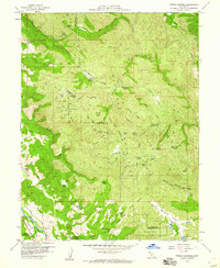
1958 Map of Purdys Gardens
USGS Topo · Published 1960About this map
Purdys Gardens and the rugged interior of the Mayacmas Mountains define this late-1950s survey of the Mendocino and Lake County borderlands. The landscape is characterized by a network of ranching outposts and high-altitude camps, including Eaglepoint Ranch, Norris Ranch, and Poor Ranch, alongside seasonal sites like South Willow Creek Camp and Knobeone Camp. This era shows the working relationship between the land and regional institutions, notably the Hopland Field Sta (Univ of Calif) and the Hopland Indian Reservation in the southern reaches.
Find a feature on this map
77 named features on this map. Tap any name to fly to it.
Don’t see what you’re looking for? This feature index may not catch every label — zoom into the map to look around manually.
Map Details
Editions of this 1958 Purdys Gardens Map
3 editions found
Other maps of this area

1920 · Ukiah
USGS Topo · 1:62,500

1921 · Kelseyville
USGS Topo · 1:62,500

1938 · Lakeport
USGS Topo · 1:62,500

1938 · Hopland
USGS Topo · 1:62,500

1943 · Kelseyville
USGS Topo · 1:62,500

1943 · Hopland
USGS Topo · 1:62,500

1944 · Ukiah
USGS Topo · 1:62,500

1944 · Hopland
USGS Topo · 1:62,500

1947 · Santa Rosa
USGS Topo · 1:250,000

1949 · Santa Rosa
USGS Topo · 1:250,000