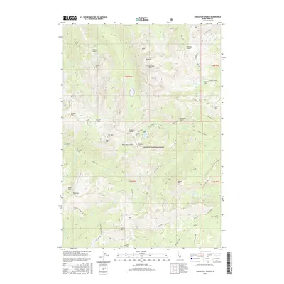
2017 Map of Purgatory Saddle
USGS Topo · Published 2017About this map
Seven Devils Mountains dominate this high-elevation terrain within the Payette National Forest, where the landscape is defined by steep ridges and glacial lakes. Named summits like Monument Peak, Pyramid Peak, and Smith Mtn overlook deep basins and gaps, such as Purgatory Saddle and Horse Pasture Basin. The water network is intricate, with drainage flowing through Black Lake Creek and the W Fork Rapid River.
Find a feature on this map
74 named features on this map. Tap any name to fly to it.
Don’t see what you’re looking for? This feature index may not catch every label — zoom into the map to look around manually.
Map Details
Editions of this 2017 Purgatory Saddle Map
This is the sole edition of this map. No revisions or reprints were ever made.
Other maps of this area

1920 · Seven Devils Mining District
USGS Topo · 1:48,000

1922 · He Devil
USGS Topo · 1:48,000

1938 · Riggins
USGS Topo · 1:96,000

1945 · Riggins
USGS Topo · 1:125,000

1955 · Grangeville
USGS Topo · 1:250,000

1957 · He Devil
USGS Topo · 1:62,500

1957 · Cuprum
USGS Topo · 1:62,500

1959 · Grangeville
USGS Topo · 1:250,000
1963 · Railroad Saddle
USGS Topo · 1:24,000
1963 · Pollock Mountain
USGS Topo · 1:24,000