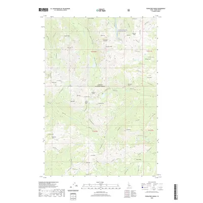
2020 Map of Purgatory Saddle
USGS Topo · Published 2020About this map
Payette National Forest dominates this high-altitude landscape in the Seven Devils Mountains, where glacial activity has carved a complex of basins and alpine lakes. The drainage patterns are defined by the Rapid Wild and Scenic River and numerous forks of Granite Creek. Evidence of historical land use and access is preserved in the location of Rankin Mill and the route of Black Lake Rd, which provides access to remote high-country water bodies like Satan Lake and Crystal Lake. Prominent summits such as Monument Peak, Smith Mtn, and Pyramid Peak surround the central Purgatory Saddle. This survey also documents the Twin Lakes (Granite Lookout) area, a significant high-point feature situated along the ridge between the Granite Fork and Twin Lakes Creek drainages.
Find a feature on this map
77 named features on this map. Tap any name to fly to it.
Don’t see what you’re looking for? This feature index may not catch every label — zoom into the map to look around manually.
Map Details
Editions of this 2020 Purgatory Saddle Map
This is the sole edition of this map. No revisions or reprints were ever made.
Other maps of this area

1920 · Seven Devils Mining District
USGS Topo · 1:48,000

1922 · He Devil
USGS Topo · 1:48,000

1938 · Riggins
USGS Topo · 1:96,000

1945 · Riggins
USGS Topo · 1:125,000

1955 · Grangeville
USGS Topo · 1:250,000

1957 · He Devil
USGS Topo · 1:62,500

1957 · Cuprum
USGS Topo · 1:62,500

1959 · Grangeville
USGS Topo · 1:250,000
1963 · Railroad Saddle
USGS Topo · 1:24,000
1963 · Pollock Mountain
USGS Topo · 1:24,000