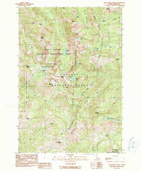
1990 Map of Purgatory Saddle
USGS Topo · Published 1990About this map
The Seven Devils Mountains dominate this high-elevation landscape, where the peaks of Pyramid Peak and White Mountain overlook a complex network of glacial basins and steep drainages. In 1990, this area within the Payette National Forest served as a critical corridor for backcountry travel and resource management, anchored by the Hells Canyon Wilderness and the Hells Canyon National Recreation Area.
Find a feature on this map
56 named features on this map. Tap any name to fly to it.
Don’t see what you’re looking for? This feature index may not catch every label — zoom into the map to look around manually.
Map Details
Editions of this 1990 Purgatory Saddle Map
2 editions found
Other maps of this area

1920 · Seven Devils Mining District
USGS Topo · 1:48,000

1922 · He Devil
USGS Topo · 1:48,000

1938 · Riggins
USGS Topo · 1:96,000

1945 · Riggins
USGS Topo · 1:125,000

1955 · Grangeville
USGS Topo · 1:250,000

1957 · He Devil
USGS Topo · 1:62,500

1957 · Cuprum
USGS Topo · 1:62,500

1959 · Grangeville
USGS Topo · 1:250,000
1963 · Railroad Saddle
USGS Topo · 1:24,000
1963 · Pollock Mountain
USGS Topo · 1:24,000