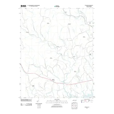
2010 Map of Purlear
USGS Topo · Published 2010About this map
Purlear and Mount Pleasant anchor a landscape defined by the branching tributaries of the Reddies River and Lewis Fork during the first decade of the 21st century. The map illustrates a rural settlement pattern where communities like Staunton and Parsonville are connected by a web of named secondary roads, such as Benny Parsons Rd and Stanton Loop Rd, reflecting deep-seated local history. Prominent terrain features, including Huffman Mountain and Rendezvous Mountain, dictate the path of waterways like Purlear Creek and Coal Creek. This topographical study also traces specific cultural landmarks like Hays Mill and Hays Arbor, alongside the winding route of the Boone Trl, which traverses the southern portion of the quadrangle. The presence of specialized identifiers like Pilgrim Baptist Church Rd highlights the central role of rural institutions in organizing the social geography of this Piedmont region.
Find a feature on this map
80 named features on this map. Tap any name to fly to it.
Don’t see what you’re looking for? This feature index may not catch every label — zoom into the map to look around manually.
Map Details
Editions of this 2010 Purlear Map
This is the sole edition of this map. No revisions or reprints were ever made.
Other maps of this area

1889 · Wilkesboro
USGS Topo · 1:125,000

1891 · Wilkesboro
USGS Topo · 1:125,000

1953 · Winston-Salem
USGS Topo · 1:250,000

1955 · Winston-Salem
USGS Topo · 1:250,000

1962 · Winston-Salem
USGS Topo · 1:250,000
1966 · Grandin
USGS Topo · 1:24,000

1966 · Boomer
USGS Topo · 1:24,000
1966 · Moravian Falls
USGS Topo · 1:24,000
1966 · Maple Springs
USGS Topo · 1:24,000

1966 · Wilkesboro
USGS Topo · 1:24,000