
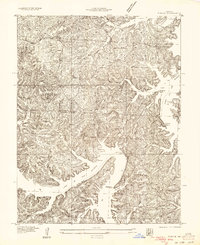
1934 Map of Purvis
USGS Topo · Published 1934About this map
The newly formed Lake of the Ozarks dominates this mid-1930s landscape, illustrating the dramatic transformation of the Osage River valley into a recreational and residential hub. The map captures the intricate shoreline of newly flooded branches, including Buck Creek and Gravois Creek, where rugged bluffs like Folsom Bluff and Hurricane Deck overlook the rising waters. This period marks the early development of Sunrise Beach and the presence of the Lakewood Club, signaling the area's shift toward a tourism-based economy shortly after the completion of Bagnell Dam.
Find a feature on this map
32 named features on this map. Tap any name to fly to it.
Don’t see what you’re looking for? This feature index may not catch every label — zoom into the map to look around manually.
Map Details
Editions of this 1934 Purvis Map
2 editions found
Other maps of this area

1888 · Versailles
USGS Topo · 1:125,000

1893 · Versailles
USGS Topo · 1:125,000

1904 · Eldon
USGS Topo · 1:62,500

1904 · Gravois Mills
USGS Topo · 1:62,500

1932 · Versailles No 4
USGS Topo · 1:48,000

1934 · Camdenton
USGS Topo · 1:24,000

1934 · Irontown Ferry
USGS Topo · 1:24,000

1934 · Lake Ozark
USGS Topo · 1:24,000

1934 · Green Bay Terrace
USGS Topo · 1:24,000

1935 · Gravois Mills
USGS Topo · 1:24,000