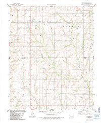
1985 Map of Putnam
USGS Topo · Published 1985About this map
Putnam sits at the northern edge of this West-Central Oklahoma landscape, where the prairie is dissected by the drainage systems of Sorter Creek, Horse Creek, and Deer Creek. The map reveals a rural community deeply integrated with the energy industry of the mid-1980s, evidenced by the extensive Oil and Gas Field and numerous scattered wells. For genealogists, the survey preserves the locations of vital community landmarks such as Merck Cem, Liberty Cem, and the Independence Ch cemetery and church site. The boundary between Dewey and Custer Counties runs through the center of the sheet, dividing the townships of Harrison, Banner, and Grant. Smaller locales like Sunset and Roseland Ch further define the social geography of this agricultural and resource-rich region.
Find a feature on this map
20 named features on this map. Tap any name to fly to it.
Don’t see what you’re looking for? This feature index may not catch every label — zoom into the map to look around manually.
Map Details
Editions of this 1985 Putnam Map
This is the sole edition of this map. No revisions or reprints were ever made.
Other maps of this area

1955 · Clinton
USGS Topo · 1:250,000

1957 · Clinton
USGS Topo · 1:250,000

1957 · Butler
USGS Topo · 1:62,500

1957 · Clinton
USGS Topo · 1:62,500

1962 · Putnam
USGS Topo · 1:62,500

1962 · Aledo
USGS Topo · 1:62,500

1976 · Butler NE
USGS Topo · 1:24,000

1976 · Clinton NW
USGS Topo · 1:24,000

1976 · Clinton NE
USGS Topo · 1:24,000
1983 · Custer City
USGS Topo · 1:24,000