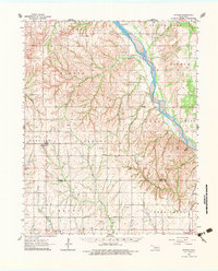
1962 Map of Putnam
USGS Topo · Published 1983About this map
The Canadian River cuts a wide path through the Oklahoma prairie in this early 1960s survey, marking the boundary for several historical townships including Little Robe and Boyd. This landscape is defined by the transition from the rolling cattle country of Dewey and Custer counties to the emerging energy infrastructure of the mid-twentieth century. Numerous Gas Wells and Drill Holes are scattered across the terrain, indicating the growth of the region's petroleum industry alongside traditional ranching.
Find a feature on this map
41 named features on this map. Tap any name to fly to it.
Don’t see what you’re looking for? This feature index may not catch every label — zoom into the map to look around manually.
Map Details
Editions of this 1962 Putnam Map
2 editions found
Other maps of this area

1955 · Clinton
USGS Topo · 1:250,000

1955 · Woodward
USGS Topo · 1:250,000

1957 · Clinton
USGS Topo · 1:250,000

1957 · Butler
USGS Topo · 1:62,500

1957 · Clinton
USGS Topo · 1:62,500

1958 · Woodward
USGS Topo · 1:250,000

1962 · Putnam
USGS Topo · 1:62,500

1962 · Aledo
USGS Topo · 1:62,500

1964 · Oakwood
USGS Topo · 1:62,500

1964 · Weatherford
USGS Topo · 1:62,500