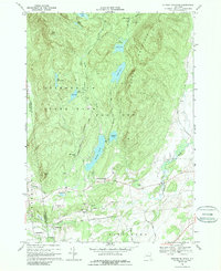
1966 Map of Putnam Mountain
USGS Topo · Published 1989About this map
Putnam Mountain dominates this mid-1960s landscape, where the southern reaches of the Adirondack State Park meet the agricultural valleys of Washington County. The transition from high timber to valley floor is marked by significant hydrological features, including the cascading Buttermilk Falls and a series of mountain-fed basins like Hadlock Pond and Lake Nebo. The map documents a period when local industry and rural life were closely linked, evident in the remnants of the Iron Furnace near Mount Hope and several active gravel pits. Small settlements like West Fort Ann and Pattens Mills serve as local hubs, while the landscape is dotted with family-named landmarks and old burial sites such as Sheldon Cem and Orcutt Cem. The winding paths of Bishop Road and Buttermilk Falls Road trace the difficult topography of the northern Adirondack foothills.
Find a feature on this map
43 named features on this map. Tap any name to fly to it.
Don’t see what you’re looking for? This feature index may not catch every label — zoom into the map to look around manually.
Map Details
Editions of this 1966 Putnam Mountain Map
2 editions found
Other maps of this area

1893 · Fort Ann
USGS Topo · 1:62,500

1893 · Whitehall
USGS Topo · 1:62,500

1895 · Whitehall
USGS Topo · 1:62,500

1895 · Fort Ann
USGS Topo · 1:62,500

1895 · Glens Falls
USGS Topo · 1:62,500

1897 · Bolton
USGS Topo · 1:62,500

1897 · Glens Falls
USGS Topo · 1:62,500

1898 · Whitehall
USGS Topo · 1:62,500

1898 · Fort Ann
USGS Topo · 1:62,500

1900 · Bolton
USGS Topo · 1:62,500