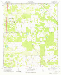
1974 Map of Putney
USGS Topo · Published 1976About this map
The boundary between Dougherty Co and Mitchell Co divides a landscape defined by agriculture and early transport routes in the mid-1970s. The Georgia Northern railroad runs diagonally across the terrain, serving as a corridor for the small settlements of Putney and Williamsburg. The map reveals a high concentration of rural spiritual centers, including Mt Moriah No 2 Ch, Antioch Ch, and Rocky Hill Ch, many of which sit alongside long-established thoroughfares such as Antioch Road and Stagecoach Road. The hydrology of the area is marked by the meandering paths of Dry Creek and Raccoon Creek, while modern infrastructure like a Pipeline and a large Substation begin to intersect with older landmarks. Genealogists and historians can trace the transition from 19th-century rural life toward late 20th-century utility and transit development.
Find a feature on this map
24 named features on this map. Tap any name to fly to it.
Don’t see what you’re looking for? This feature index may not catch every label — zoom into the map to look around manually.
Map Details
Editions of this 1974 Putney Map
2 editions found
Other maps of this area

1953 · Dothan
USGS Topo · 1:250,000

1953 · Waycross
USGS Topo · 1:250,000

1954 · Dothan
USGS Topo · 1:250,000

1955 · Dothan
USGS Topo · 1:250,000

1956 · Albany East
USGS Topo · 1:24,000

1956 · Albany West
USGS Topo · 1:24,000

1956 · Baconton
USGS Topo · 1:62,500

1956 · Sylvester
USGS Topo · 1:62,500

1956 · Doerun
USGS Topo · 1:62,500

1956 · Albany
USGS Topo · 1:62,500