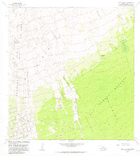
1981 Map of Puu O Keokeo
USGS Topo · Published 1981About this map
The volcanic landscape of the Southwest Rift Zone dominates this 1981 survey, where the physical history of the island is mapped through successive eras of activity. Chronological records of the Kahuku Lava Flow of 1926, the Lava Flow of 1916, and the Lava Flow of 1887 illustrate how the terrain has been reshaped by the Mauna Loa eruptions. Amidst these flows are islands of older vegetation known as kipukas, including Kipuka Nene and Kipuka Akala, which stand out against the raw basalt. Evidence of human presence is found in the scattered remnants of Wright Camp (Site) and the Halepohaha (Ruins), while the dense Kau Forest Reserve and Kiolakaa - Keaaiohinu cover the southeastern slopes. To the southwest, a modern road network with labels like Mahimahi Blvd and Outrigger Drive shows the early stages of local residential development.
Find a feature on this map
27 named features on this map. Tap any name to fly to it.
Don’t see what you’re looking for? This feature index may not catch every label — zoom into the map to look around manually.
Map Details
Editions of this 1981 Puu O Keokeo Map
This is the sole edition of this map. No revisions or reprints were ever made.
Other maps of this area

1924 · Honuapo
USGS Topo · 1:62,500

1928 · Mauna Loa
USGS Topo · 1:62,500

1928 · Hoopuloa
USGS Topo · 1:62,500

1954 · Hawaii South
USGS Topo · 1:250,000

1959 · Hawaii South
USGS Topo · 1:250,000

1961 · Hawaii South
USGS Topo · 1:250,000

1962 · Hawaii South
USGS Topo · 1:250,000

1962 · Kahuku Ranch
USGS Topo · 1:24,000

1962 · Pohue Bay
USGS Topo · 1:24,000

1962 · Papa
USGS Topo · 1:24,000