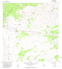
1982 Map of Puu Oo
USGS Topo · Published 1982About this map
Lava Flow of 1843 and subsequent volcanic deposits from 1855, 1881, 1899, and 1935 dominate this high-altitude landscape on the Big Island. The central artery of Saddle Road cuts across the lava fields, connecting isolated outposts like the Humuula Sheep Station and Kalaieha. This region is a study in land management and utility, where the Pohakuloa Training Area sits adjacent to vast protected lands including the Kaohe Forest Reserve and Mauna Loa Forest Reserve. High-elevation ranching is evidenced by the Puu Oo Ranch and several water tanks and reservoirs scattered across the terrain. Notable cinder cones like Puu Oo, Puu Kole, and Puu Kahiliku punctuate the landscape, serving as prominent landmarks for navigation across the open terrain. Smaller settlements such as Hookomo and Omaokoili mark the sparse human footprint in this volcanic environment.
Find a feature on this map
34 named features on this map. Tap any name to fly to it.
Don’t see what you’re looking for? This feature index may not catch every label — zoom into the map to look around manually.
Map Details
Editions of this 1982 Puu Oo Map
This is the sole edition of this map. No revisions or reprints were ever made.
Other maps of this area

1927 · Kaohe
USGS Topo · 1:62,500

1930 · Humuula
USGS Topo · 1:62,500

1930 · Kaohe
USGS Topo · 1:62,500

1954 · Hawaii North
USGS Topo · 1:250,000

1956 · Puu Oo
USGS Topo · 1:24,000

1956 · Pua Akala
USGS Topo · 1:24,000

1956 · Puu Koli
USGS Topo · 1:24,000

1956 · Upper Piihonua
USGS Topo · 1:24,000
1956 · Puu Ulaula
USGS Topo · 1:24,000
1956 · Kulani
USGS Topo · 1:24,000