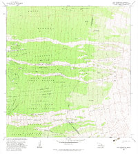
1982 Map of Puu Pohakuloa
USGS Topo · Published 1982About this map
The Honokua Lava Flow of 1950 dominates this upland landscape, carving distinct paths through the lush South Kona Forest Reserve. These recent geologic events are mapped alongside older agricultural land divisions, including the Kukuiopae Homesteads and Haukalua 2 Homesteads, illustrating the historical push for settlement on the volcanic slopes. The terrain is marked by essential water infrastructure for ranching and survival, such as the Lumiawai Waterhole and several Rain Sheds scattered at high elevations. Tracing the Trail and various 4WD routes reveals a network connecting isolated locations like Hopper Camp and Kaohe Ranch to the more prominent peak of Puu Pohakuloa. The map documents a rugged transition where human industry, represented by a Corral and named land tracts, meets the raw, advancing power of Hawaiian lava flows.
Find a feature on this map
53 named features on this map. Tap any name to fly to it.
Don’t see what you’re looking for? This feature index may not catch every label — zoom into the map to look around manually.
Map Details
Editions of this 1982 Puu Pohakuloa Map
2 editions found
Other maps of this area

1924 · Honuapo
USGS Topo · 1:62,500

1928 · Mauna Loa
USGS Topo · 1:62,500

1928 · Hoopuloa
USGS Topo · 1:62,500

1954 · Hawaii South
USGS Topo · 1:250,000

1959 · Hawaii South
USGS Topo · 1:250,000

1959 · Honaunau
USGS Topo · 1:24,000
1960 · Kaunene
USGS Topo · 1:24,000

1961 · Hawaii South
USGS Topo · 1:250,000

1962 · Hawaii South
USGS Topo · 1:250,000

1962 · Milolii
USGS Topo · 1:24,000