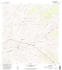
1982 Map of Puu Ulaula
USGS Topo · Published 1982About this map
Hawaii Volcanoes National Park and the Mauna Loa Forest Reserve converge in this high-altitude landscape dominated by the volcanic activity of the Northeast Rift Zone. The terrain is meticulously cataloged by the chronology of its eruptive history, featuring distinct flows such as the Lava Flow of 1855, the Lava Flow of 1899, and the more recent Lava Flow of 1942. This sequence of flows provides a detailed record of the mountain's transformative power over a century of geologic time.
Find a feature on this map
26 named features on this map. Tap any name to fly to it.
Don’t see what you’re looking for? This feature index may not catch every label — zoom into the map to look around manually.
Map Details
Editions of this 1982 Puu Ulaula Map
2 editions found
Other maps of this area

1921 · Kilauea
USGS Topo · 1:62,500

1924 · Kilauea
USGS Topo · 1:62,500

1927 · Kaohe
USGS Topo · 1:62,500

1928 · Mauna Loa
USGS Topo · 1:62,500

1930 · Humuula
USGS Topo · 1:62,500

1930 · Kaohe
USGS Topo · 1:62,500

1954 · Hawaii South
USGS Topo · 1:250,000

1954 · Hawaii North
USGS Topo · 1:250,000

1956 · Puu Oo
USGS Topo · 1:24,000

1956 · Puu Koli
USGS Topo · 1:24,000