
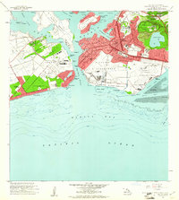
1953 Map of Puuloa
USGS Topo · Published 1956About this map
Pearl Harbor serves as the central focal point of this mid-century survey, surrounded by a landscape of intensive military and aviation development. The map details the complex geography of the lochs, including West Loch, Middle Loch, and East Loch, which frame the Waipio Peninsula and Ford Island. To the east, the volcanic terrain of Aliamanu Crater and Makalapa Crater stands in contrast to the expanding infrastructure of the Honolulu International Airport and its seaplane runways in Keehi Lagoon.
Find a feature on this map
55 named features on this map. Tap any name to fly to it.
Don’t see what you’re looking for? This feature index may not catch every label — zoom into the map to look around manually.
Map Details
Editions of this 1953 Puuloa Map
This is the sole edition of this map. No revisions or reprints were ever made.
Other maps of this area

1953 · Schofield Barracks
USGS Topo · 1:24,000

1953 · Honolulu
USGS Topo · 1:24,000

1953 · Ewa
USGS Topo · 1:24,000

1954 · Oahu
USGS Topo · 1:250,000

1954 · Kaneohe
USGS Topo · 1:24,000

1954 · Waipahu
USGS Topo · 1:24,000

1959 · Kaneohe
USGS Topo · 1:24,000

1959 · Honolulu
USGS Topo · 1:24,000

1959 · Waipahu
USGS Topo · 1:24,000
1959 · Puuloa
USGS Topo · 1:24,000