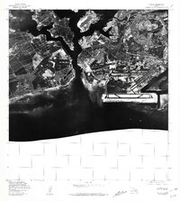
1981 Map of Puuloa
USGS Topo · Published 1981About this map
Pacific Ocean waters dominate the southern half of this 1981 orthophotoquad, which captures the coastal transformation of the Honolulu area during the late 1970s. Created from aerial photography taken between 1976 and 1978, the map reveals a landscape of intense development and military-industrial infrastructure. Distinctive coastal markers such as Keahi Point and Ahua Pt define the jagged shoreline, where runways and shipping channels have been carved into the land. Unlike a standard topographic map, this photographic record provides a direct visual of the urban density and the intricate geometry of the airfields and harbor facilities as they existed just before the turn of the decade. It serves as a stark visual reference for the massive land reclamation and civil engineering projects that reshaped this portion of the Hawaiian coast.
Find a feature on this map
3 named features on this map. Tap any name to fly to it.
Don’t see what you’re looking for? This feature index may not catch every label — zoom into the map to look around manually.
Map Details
Editions of this 1981 Puuloa Map
This is the sole edition of this map. No revisions or reprints were ever made.
Other maps of this area

1953 · Schofield Barracks
USGS Topo · 1:24,000

1953 · Honolulu
USGS Topo · 1:24,000

1953 · Ewa
USGS Topo · 1:24,000

1953 · Puuloa
USGS Topo · 1:24,000

1954 · Oahu
USGS Topo · 1:250,000

1954 · Kaneohe
USGS Topo · 1:24,000

1954 · Waipahu
USGS Topo · 1:24,000

1959 · Kaneohe
USGS Topo · 1:24,000

1959 · Honolulu
USGS Topo · 1:24,000

1959 · Waipahu
USGS Topo · 1:24,000