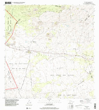
1995 Map of Puuoo
USGS Topo · Published 2001About this map
The Humu'ula Saddle serves as a high-altitude corridor between the towering volcanic masses of Hawaii, documented here in the mid-1990s. The landscape is a stark record of volcanic activity, defined by the extensive Lava Flow of 1843 and the Lava Flow of 1935 that snake across the terrain. Amidst these flows, the Humu'ula Sheep Station and Pu'u'o'o Ranch represent the enduring presence of high-country ranching in this demanding environment.
Find a feature on this map
33 named features on this map. Tap any name to fly to it.
Don’t see what you’re looking for? This feature index may not catch every label — zoom into the map to look around manually.
Map Details
Editions of this 1995 Puuoo Map
This is the sole edition of this map. No revisions or reprints were ever made.
Other maps of this area

1927 · Kaohe
USGS Topo · 1:62,500

1930 · Humuula
USGS Topo · 1:62,500

1930 · Kaohe
USGS Topo · 1:62,500

1954 · Hawaii North
USGS Topo · 1:250,000

1956 · Puu Oo
USGS Topo · 1:24,000

1956 · Pua Akala
USGS Topo · 1:24,000

1956 · Puu Koli
USGS Topo · 1:24,000

1956 · Upper Piihonua
USGS Topo · 1:24,000
1956 · Puu Ulaula
USGS Topo · 1:24,000
1956 · Kulani
USGS Topo · 1:24,000