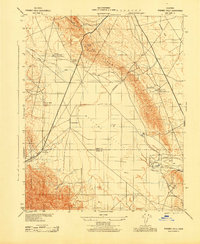
1943 Map of Pyramid Hills
USGS Topo · Published 1943About this map
The McClure Valley and the Kettleman Plain dominate this 1940s landscape, illustrating the intersection of California's agricultural expansion and early oil industry. The boundary between Kings and Kern counties bisects the terrain, which is defined by the sharp rise of the Pyramid Hills and the Tent Hills. Human settlement is sparse, centered around the Orchard Ranch and the home of A M Barker, suggesting a region where ranching and resource extraction were the primary drivers of development.
Find a feature on this map
21 named features on this map. Tap any name to fly to it.
Don’t see what you’re looking for? This feature index may not catch every label — zoom into the map to look around manually.
Map Details
Editions of this 1943 Pyramid Hills Map
This is the sole edition of this map. No revisions or reprints were ever made.
Other maps of this area

1914 · Lost Hills
USGS Topo · 1:125,000

1914 · Cholame
USGS Topo · 1:125,000

1915 · Cholame
USGS Topo · 1:125,000

1917 · Cholame
USGS Topo · 1:125,000

1930 · Avenal Gap
USGS Topo · 1:31,680

1930 · Kettleman Plain
USGS Topo · 1:31,680

1930 · Middle Dome
USGS Topo · 1:31,680

1933 · Avenal Gap
USGS Topo · 1:31,680

1933 · Kettleman Plain
USGS Topo · 1:31,680

1934 · Reef Ridge
USGS Topo · 1:31,680