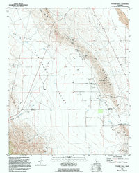
1994 Map of Pyramid Hills
USGS Topo · Published 1994About this map
The industrial and agricultural interface of the Pyramid Hills is captured here as they separate the Sunflower Valley to the west from the Kettleman Plain to the east. This 1994 edition reveals a landscape heavily utilized for energy and mineral extraction, dominated by the Devils Den Oil Field and numerous scattered oil wells and sumps. Large-scale resource operations are further evidenced by Gypsum deposits and Quarries located along the eastern slopes of the hills.
Find a feature on this map
24 named features on this map. Tap any name to fly to it.
Don’t see what you’re looking for? This feature index may not catch every label — zoom into the map to look around manually.
Map Details
Editions of this 1994 Pyramid Hills Map
This is the sole edition of this map. No revisions or reprints were ever made.
Other maps of this area

1914 · Lost Hills
USGS Topo · 1:125,000

1914 · Cholame
USGS Topo · 1:125,000

1915 · Cholame
USGS Topo · 1:125,000

1917 · Cholame
USGS Topo · 1:125,000

1930 · Avenal Gap
USGS Topo · 1:31,680

1930 · Kettleman Plain
USGS Topo · 1:31,680

1930 · Middle Dome
USGS Topo · 1:31,680

1933 · Avenal Gap
USGS Topo · 1:31,680

1933 · Kettleman Plain
USGS Topo · 1:31,680

1934 · Reef Ridge
USGS Topo · 1:31,680