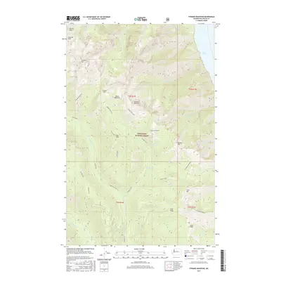
2017 Map of Pyramid Mountain
USGS Topo · Published 2017About this map
Lake Chelan anchors the northeastern corner of this landscape, its deep waters bordered by the steep, high-elevation terrain of the Wenatchee National Forest. The topography is dominated by the Chelan Mountains, featuring prominent summits such as Cardinal Peak, Emerald Peak, and Pyramid Mountain. These peaks are connected by high-altitude features like Grouse Pass and long ridgelines including Pugh Ridge and Bearcat Ridge. Drainage patterns are clearly defined, with the Entiat River and its North Fork flowing through the southern portion of the quadrangle. The map details a complex network of creeks such as Pyramid Creek and Graham Harbor Creek that descend from the interior heights toward the lake and river valleys. For those studying the geography of this wilderness area, Pyramid View Point and the remote Pope Ridge Road indicate the primary routes and vantage points used for forest management and back-country access.
Find a feature on this map
41 named features on this map. Tap any name to fly to it.
Don’t see what you’re looking for? This feature index may not catch every label — zoom into the map to look around manually.
Map Details
Editions of this 2017 Pyramid Mountain Map
This is the sole edition of this map. No revisions or reprints were ever made.
Other maps of this area

1899 · Methow
USGS Topo · 1:125,000

1901 · Chelan
USGS Topo · 1:125,000

1901 · Methow
USGS Topo · 1:125,000

1901 · Chiwaukum
USGS Topo · 1:125,000

1902 · Stehekin
USGS Topo · 1:125,000

1904 · Stehekin
USGS Topo · 1:125,000

1904 · Chiwaukum
USGS Topo · 1:125,000

1944 · Lucerne
USGS Topo · 1:62,500

1949 · Lucerne
USGS Topo · 1:62,500

1955 · Concrete
USGS Topo · 1:250,000