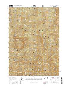
2014 Map of Quail Prairie Mountain
USGS Topo · Published 2014About this map
Siskiyou National Forest covers this stretch of the Klamath Mountains, a region defined by complex ridges and deep river drainages in the early 21st century. The Chetco River and its S Fork Chetco River carve through the terrain, joined by numerous tributaries including Boulder Cr and Emily Cr. High points such as Quail Prairie Mountain and Snaketooth Butte provide significant vertical relief, while landforms like Devils Backbone and Moores Ridge trace the divide between watersheds. A network of Forest Service roads, including Nat For Dev Rd 1909 and High Prairie Rd, provides the only vehicular access to these remote slopes. Unique local names like Swede Heaven and Pollywog Butte reflect the long history of land management and recreation within the federal forest boundaries.
Find a feature on this map
33 named features on this map. Tap any name to fly to it.
Don’t see what you’re looking for? This feature index may not catch every label — zoom into the map to look around manually.
Map Details
Editions of this 2014 Quail Prairie Mountain Map
This is the sole edition of this map. No revisions or reprints were ever made.
Other maps of this area

1917 · Kerby
USGS Topo · 1:125,000

1918 · Kerby
USGS Topo · 1:125,000

1945 · Kerby
USGS Topo · 1:125,000

1954 · Coos Bay
USGS Topo · 1:250,000

1954 · Chetco Peak
USGS Topo · 1:62,500

1954 · Collier Butte
USGS Topo · 1:62,500

1954 · Mt. Emily
USGS Topo · 1:62,500

1954 · Pearsoll Peak
USGS Topo · 1:62,500

1955 · Medford
USGS Topo · 1:250,000

1957 · Medford
USGS Topo · 1:250,000