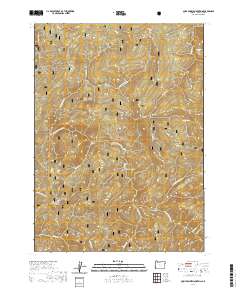
2020 Map of Quail Prairie Mountain
USGS Topo · Published 2020About this map
The Siskiyou National Forest dominates this landscape in Curry County, where the terrain is defined by a dense network of high ridges and narrow river valleys. High points such as Quail Prairie Mtn and Snaketooth Butte rise above deep drainages, while the Chetco Wild and Scenic River carves through the western portion of the quadrangle. The map reveals the isolation of places like Swede Heaven and Red Mountain Prairie, and traces the complex system of forest roads that navigate between landmarks like Devils Backbone and Pollywog Butte. The density of named ridges—including Panda Ridge, Moores Ridge, and Long Ridge—illustrates the intricate topography of the Southern Oregon Coast Range and the importance of these landforms for navigation and resource management within the national forest system.
Find a feature on this map
30 named features on this map. Tap any name to fly to it.
Don’t see what you’re looking for? This feature index may not catch every label — zoom into the map to look around manually.
Map Details
Editions of this 2020 Quail Prairie Mountain Map
This is the sole edition of this map. No revisions or reprints were ever made.
Other maps of this area

1917 · Kerby
USGS Topo · 1:125,000

1918 · Kerby
USGS Topo · 1:125,000

1945 · Kerby
USGS Topo · 1:125,000

1954 · Coos Bay
USGS Topo · 1:250,000

1954 · Chetco Peak
USGS Topo · 1:62,500

1954 · Collier Butte
USGS Topo · 1:62,500

1954 · Mt. Emily
USGS Topo · 1:62,500

1954 · Pearsoll Peak
USGS Topo · 1:62,500

1955 · Medford
USGS Topo · 1:250,000

1957 · Medford
USGS Topo · 1:250,000