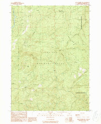
1989 Map of Quail Prairie Mtn
USGS Topo · Published 1989About this map
Siskiyou National Forest dominates this 1980s landscape, where the Chetco River carves through the western reaches of the quadrangle. High points like Quail Prairie Mountain and its Lookout Tower provide panoramic views of a terrain defined by steep ridges and distinct natural clearings. This map illustrates the transition from managed forest land to the protected Kalmiopsis Wilderness in the east, marked by the Wilderness Boundary. Local geography is punctuated by evocatively named features such as Swede Heaven, Pollywog Butte, and Snaketooth Butte. The drainage network is dense, with Prairie Creek and Moores Creek feeding the primary river system. A few Quarry sites and a network of 4wd roads and trails highlight the limited human activity within this largely undeveloped mountain region during the late twentieth century.
Find a feature on this map
29 named features on this map. Tap any name to fly to it.
Don’t see what you’re looking for? This feature index may not catch every label — zoom into the map to look around manually.
Map Details
Editions of this 1989 Quail Prairie Mtn Map
This is the sole edition of this map. No revisions or reprints were ever made.
Other maps of this area

1917 · Kerby
USGS Topo · 1:125,000

1918 · Kerby
USGS Topo · 1:125,000

1945 · Kerby
USGS Topo · 1:125,000

1954 · Coos Bay
USGS Topo · 1:250,000

1954 · Chetco Peak
USGS Topo · 1:62,500

1954 · Collier Butte
USGS Topo · 1:62,500

1954 · Mt. Emily
USGS Topo · 1:62,500

1954 · Pearsoll Peak
USGS Topo · 1:62,500

1955 · Medford
USGS Topo · 1:250,000

1957 · Medford
USGS Topo · 1:250,000