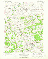
1955 Map of Quarryville
USGS Topo · Published 1966About this map
Strasburg Boro and the namesake hub of Quarryville anchor this mid-century landscape in Lancaster County, defined by a dense network of rural schools and small agricultural settlements. The terrain transitions from the lower valley floor near Pequea Creek toward the elevation of Mine Ridge and Strasburg Hill in the east. Regional infrastructure is notably varied, featuring the Strasburg Railroad and a Fish Hatchery near New Providence.
Find a feature on this map
60 named features on this map. Tap any name to fly to it.
Don’t see what you’re looking for? This feature index may not catch every label — zoom into the map to look around manually.
Map Details
Editions of this 1955 Quarryville Map
4 editions found
Other maps of this area

1902 · Lancaster
USGS Topo · 1:62,500

1904 · Lancaster
USGS Topo · 1:62,500

1906 · New Holland
USGS Topo · 1:62,500

1908 · New Holland
USGS Topo · 1:62,500

1912 · Quarryville
USGS Topo · 1:62,500

1912 · Mc Calls Ferry
USGS Topo · 1:62,500

1941 · New Holland
USGS Topo · 1:62,500

1943 · Lancaster
USGS Topo · 1:62,500

1943 · Quarryville
USGS Topo · 1:62,500

1943 · Mc Calls Ferry
USGS Topo · 1:62,500
Featured Places
- West Lampeter Township, PA
- Willow Street, West Lampeter Township
- Paradise Township, PA
- Quarryville, PA
- Strasburg, PA