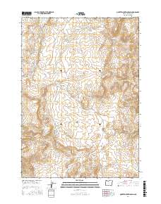
2017 Map of Quartz Mountain Basin
USGS Topo · Published 2017About this map
Quartz Mountain Basin defines this high-desert landscape in Malheur County, where water is the primary driver of name and place. A series of scattered springs, including Mattingly Spring, Diamond Spring, and Cow Camp Spring, suggest the historical importance of this area for livestock and seasonal camps. These small water sources are critical waypoints amidst the high-elevation terrain of Quartz Mtn and Black Butte. The map reveals a land divided by drainage and relief, from the depths of Red Butte Canyon to the sharp descents of Deadman Gulch and Acton Gulch. The northern portion of the quadrangle is anchored by Homestead Reservoir, a vital piece of water infrastructure. This survey provides a precise look at the township and range divisions of the Public Land Survey System, showing the intersection of T24S R43E and T25S R43E across a sparsely populated region of eastern Oregon.
Find a feature on this map
20 named features on this map. Tap any name to fly to it.
Don’t see what you’re looking for? This feature index may not catch every label — zoom into the map to look around manually.
Map Details
Editions of this 2017 Quartz Mountain Basin Map
This is the sole edition of this map. No revisions or reprints were ever made.
Other maps of this area

1906 · Mitchell Butte
USGS Topo · 1:125,000

1955 · Boise
USGS Topo · 1:250,000

1958 · Boise
USGS Topo · 1:250,000

1962 · Boise
USGS Topo · 1:250,000

1967 · Pelican Point
USGS Topo · 1:24,000

1967 · Diamond Butte
USGS Topo · 1:24,000
1967 · The Elbow
USGS Topo · 1:24,000

1967 · Twin Springs
USGS Topo · 1:24,000

1967 · Rooster Comb
USGS Topo · 1:24,000

1967 · Quartz Mtn Basin
USGS Topo · 1:24,000