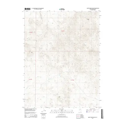
2014 Map of Quartz Mountain NW
USGS Topo · Published 2014About this map
Broken Hills anchors the southern portion of this high-desert Nevada landscape, situated within a basin defined by complex topographic shifts. The terrain is characterized by the arid drainages of Gabbs Wash and the presence of Mud Spring, a critical water source in an otherwise dry expanse. The elevation rises toward the northeast with the East Gate Range, where the map documents steep contours and prominent landforms like Grayback and Iron Rock. This area, surveyed during the early 21st century, reflects the persistent geographic isolation of Churchill County. The lack of major modern infrastructure on this 2014 sheet suggests a landscape largely unchanged in its fundamental layout, where natural features and township boundaries dictate the human understanding of the territory. Researchers can trace the drainage patterns that define the region's seasonal water movement across this part of the Great Basin.
Find a feature on this map
10 named features on this map. Tap any name to fly to it.
Don’t see what you’re looking for? This feature index may not catch every label — zoom into the map to look around manually.
Map Details
Editions of this 2014 Quartz Mountain NW Map
This is the sole edition of this map. No revisions or reprints were ever made.
Other maps of this area

1908 · Carson Sink
USGS Topo · 1:250,000

1910 · Carson Sink
USGS Topo · 1:250,000

1955 · Millett
USGS Topo · 1:250,000

1957 · Reno
USGS Topo · 1:250,000

1959 · Reno
USGS Topo · 1:250,000

1959 · Millett
USGS Topo · 1:250,000

1960 · Reno
USGS Topo · 1:250,000
1969 · Quartz Mtn
USGS Topo · 1:24,000
1969 · Quartzite Mtn NW
USGS Topo · 1:24,000

1969 · Desatoya Peak
USGS Topo · 1:24,000