
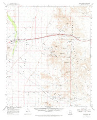
1962 Map of Quartzsite
USGS Topo · Published 1964About this map
The Plomosa Mountains and Posa Plain anchor this mid-century survey of the Arizona desert, revealing a landscape defined by mining history and early travel routes. The settlement of Quartzsite serves as the primary hub, where the Hi Jolly Monument and Cem reflect the area’s unique cultural heritage. To the east of town, the remains of Old Fort Tyson stand near the Tyson Wash, highlighting the strategic importance of water and shelter in this arid region.
Find a feature on this map
56 named features on this map. Tap any name to fly to it.
Don’t see what you’re looking for? This feature index may not catch every label — zoom into the map to look around manually.
Map Details
Editions of this 1962 Quartzsite Map
2 editions found
Other maps of this area

1930 · Linskey
USGS Topo · 1:62,500

1931 · Moon Mtn
USGS Topo · 1:62,500

1932 · Moon Mtn
USGS Topo · 1:62,500

1933 · Cunningham Mtn
USGS Topo · 1:48,000

1934 · Trigo Peaks
USGS Topo · 1:48,000

1939 · Trigo Peaks
USGS Topo · 1:62,500

1940 · Dome Rock Mts
USGS Topo · 1:62,500

1942 · Blythe
USGS Topo · 1:250,000

1942 · Vicksburg
USGS Topo · 1:250,000

1942 · MOON MTN
USGS Topo · 1:62,500